1. Why Kefalonia looks modern — and why Fiskardo doesn't
On 12 August 1953, a 6.4-magnitude earthquake struck Kefalonia. Two days later, a 7.2-magnitude quake hit the same area. The combined damage was catastrophic: the Greek government's own estimates put the destruction of inhabited buildings at 96%, making it one of the most total erasures of built environment from a single seismic event in modern European history. The islands of Ithaca and Zakynthos were damaged in the same sequence; Kefalonia suffered worst.
International reconstruction aid — primarily from the United States and the United Kingdom under the Marshall Plan framework — arrived quickly, and the island was rebuilt in concrete through the late 1950s and 1960s. Argostoli, the capital, was built from zero. Lixouri, the second city, was built from zero. The market towns of Sami, Poros, and Skala were built from zero. The result is a Kefalonia that looks, in most places, like a competent mid-century Greek town: functional, reasonably attractive, and without architectural depth.
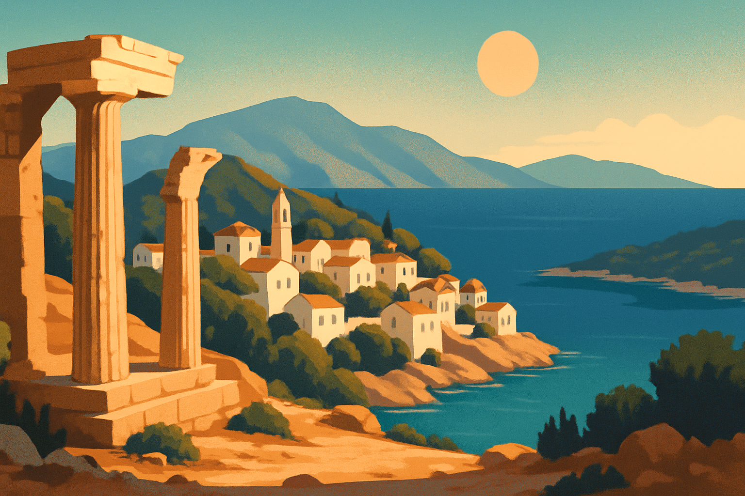
Fiskardo is the exception. Located at the island's northernmost point, it sits on dense limestone bedrock that absorbed rather than amplified the seismic waves. The village survived with minimal damage, leaving intact a complete ensemble of Venetian-era houses, merchant storage vaults, tiled roofs, and harbour walls — the only such ensemble remaining anywhere in the Ionian islands. Every other comparable village was either destroyed in 1953 or had already been modernised out of existence before that. Walking Fiskardo's harbour is walking through a document of how the entire region looked before the earthquake changed everything.
2. Fiskardo: the harbour, the Norman duke, and the Byzantine lighthouse
Fiskardo takes its name from Robert Guiscard — the Norman duke who captured the Ionian islands in 1085, died here of illness before he could continue to his intended target of Constantinople, and gave the village his name in a garbled Greek transliteration. The harbour has been operational since before Norman rule; the Venetians used it as a provisioning stop on their eastern Mediterranean routes, which explains why the architecture here is Venetian rather than locally Greek.
The harbour front is the main event: a curve of two- and three-storey buildings in the characteristic Ionian style — ochre and rose plaster facades, wooden shutters, stone window surrounds, tiled roofs — reflected in a clear turquoise bay. The lower buildings with heavy stone arches were Venetian storage vaults for goods in transit; the upper floors were merchant residences. The restaurants that now occupy these spaces charge accordingly (dinner at the water runs €40–50 per person), but the architecture is entirely authentic.
Walk ten minutes north along the coastal path to reach the Byzantine lighthouse — the oldest lighthouse still standing in Greece, built in the 1st or 2nd century AD to guide ships through the channel between Kefalonia and Ithaca. From the platform you look directly across the water to Ithaca, the island that Homer made the destination Odysseus spent twenty years trying to reach. The distance is about 3 kilometres. Tassia on the harbour front has been cooking Kefalonite seafood since the 1970s under owner-chef Tassia Dendriou, who has written several cookbooks on Ionian cuisine. The fresh-caught fish and the octopus stifado are prepared with clarity that justifies the prices.
3. Myrtos Beach: what the photographs don't prepare you for
Myrtos Beach appears in every list of Europe's most beautiful beaches, and the photographs show why: brilliant white pebbles, water ranging from pale turquoise to deep cobalt by depth, and vertical limestone cliffs rising 200 meters on both sides. The contrast is more intense in person than on screen.
What photographs don't convey is the physical situation. The beach sits at the bottom of a switchback descent from the cliff road above — the road is spectacular to drive but genuinely narrow in sections, and two large vehicles meeting head-on requires one to reverse to a passing point. In peak season (late July and August) this creates a queue both directions. The practical solution is early arrival: between 8 and 9:30 a.m. the road is manageable and the beach, which runs 800 meters long, is uncrowded. By 11 a.m. the experience has changed considerably.
Myrtos faces north, which means afternoon shade from the cliffs in late summer and significant wave action when a north wind is running. The beach drops steeply — deep water begins within a few meters of the shoreline — which makes it unsuitable for weak swimmers in any wind, but excellent for snorkeling when calm. The rock formations at both ends hold sea urchins and occasional octopus; visibility runs to 8 meters on a flat day.
The nearest services are in Divarata, 5 kilometers up the cliff road. There is a beach kiosk, operational in peak season, but at resort prices. Buy water before descending.
4. Melissani Cave: the myth, the light, and the 14-kilometre underground river
Melissani Cave, near the village of Sami on the eastern coast, contains an underground lake 160 meters long and 40 meters wide. The cave ceiling collapsed approximately 5,000 years ago, leaving an opening that now admits direct sunlight for a two-hour window each morning. When the angle is right — roughly 10 to 11:30 a.m. — the reflected light turns the water a luminous blue-green that has no natural equivalent in above-ground water.
Ancient Greeks identified the site as a sanctuary of Pan and the nymphs. A terracotta figurine of Pan was discovered during the cave's archaeological excavation in 1953 — the same year as the earthquake — confirming the site's ritual use over at least two millennia. The cave is named for the nymph Melissani, who according to local tradition drowned herself in the lake when her love for Pan was refused. The cave was not opened to visitors until 1963, after the archaeological survey was complete.
Visiting: the entrance is 2 kilometers north of Sami on the road toward Agia Efimia. You descend through a cut tunnel to a concrete dock where flat-bottomed boats depart for 20-minute tours of both chambers — the open chamber with the light, and the enclosed chamber where the water is darker and calmer. The boatmen row by hand. Cost is approximately €8; continuous departures in summer. Photography is permitted but difficult: the contrast between direct sunlight on the water and the dark cave walls requires significant exposure adjustment.
In the 1960s, scientists poured fluorescent dye into seawater near Argostoli and watched it emerge in the Melissani lake 14 days later. The underground channel connecting them — roughly 14 kilometers through unexplored limestone — remains uncharted.
5. What to eat in Kefalonia
Kefalonite cuisine carries 400 years of Venetian influence alongside the island's own agricultural identity: excellent olive oil, lamb and goat from the interior highlands, aged local cheeses, and the singular Robola grape. The results are more complex and specific than what you find on most Greek islands.
Kreatopita is the island's defining dish — a meat pie unlike anything in the spanakopita family. Slow-cooked lamb or goat is mixed with rice (which absorbs the cooking juices), local mountain oregano, and sometimes cheese, then sealed in a thick layered phyllo crust and baked until dense and fragrant. It is cut in wedges and served as a main course or morning snack. Every household has a version; the ones in rural kafeneions in the hill villages above Sami and in the Omala Valley are consistently better than the harbour-restaurant iterations made for tourists.
Pastitsada is the Venetian-inherited centerpiece of Kefalonite cooking: rooster or veal braised for hours in a sauce of tomato, wine, cinnamon, cloves, and allspice, served over thick tubular pasta called kofto. The spice combination — especially the cinnamon and allspice — reflects the Venetian spice trade that once passed through Fiskardo's storage vaults. Argonavis in Argostoli's old harbour district makes a reliable version.
Mandoles are the island's signature sweet: caramelized almonds in toffee, cooled and broken into shards. Every food shop sells them. Unspectacular in description, difficult to stop eating in practice.
Robola wine: the Omala Valley limestone produces a dry white with high acidity, citrus and mineral finish, and almost no international distribution. The Robola Cooperative in Razata sells estate bottles for €8–12 with tastings. If you drink wine, this stop warrants the 20-minute detour from Argostoli.
6. Argostoli: the rebuilt capital, the lagoon, and where to watch sea turtles for free
Argostoli was constructed from the ground up after 1953 and lacks the historical texture of older Greek capitals. What it has is a genuinely pleasant harbour setting, a working market town that hasn't been fully converted to tourism, and one of the most accessible sea turtle observation points in Greece.
The Koutavos Lagoon sits behind the harbour, separated from the open sea by the Drapanos Bridge — a stone causeway built by the British in 1813 during their colonial administration of the Ionian islands (Britain controlled the region from 1815 to 1864). The lagoon is brackish and ecologically rich. Loggerhead sea turtles (Caretta caretta) feed here in summer, and they surface reliably enough that Argostoli harbour has become one of the few places in Greece where you can watch wild turtles from land without a boat ticket. Walk the southern side of the Drapanos Bridge between 7 and 9 a.m. when light is low and turtles are near the surface. The Kefalonia Turtle Conservation Project maintains information boards along the harbour and can direct you to nesting beach locations.
Argostoli's Lithostroto — the pedestrianized central street running from Plateia Vallianou south toward the market — has the island's best independent shops and a cluster of kafeneions and ouzeris that serve food at non-Fiskardo prices. The Archaeological Museum at Vergoti Street 12 holds Mycenaean burial site finds from the island's interior — including gold jewellery and bronze weapons from sites near Sami — that are not available anywhere outside Kefalonia. Open Tuesday to Sunday, €6.
7. How to get to Kefalonia, how long to stay, and the best time to go
How long to stay? Kefalonia is 904 square kilometers — the sixth-largest island in Greece — and requires a car to see properly. A meaningful visit needs at least 4 full days: one for Argostoli and the lagoon, one to drive the west coast to Myrtos and continue north to Fiskardo, one for Sami and Melissani Cave on the east coast, and one for the interior villages and the Robola Cooperative. A week allows an unhurried version.
Getting there: From Athens, Olympic Air and Sky Express both fly to Kefalonia Airport (EFL), 9 kilometers south of Argostoli, in under an hour. Car rental is available at the airport and effectively mandatory. By sea from the Peloponnese: ferries from Killini reach Poros in about 90 minutes; ferries from Patras reach Sami in roughly 3 hours. From the north, a ferry connects Fiskardo to Lefkada and Ithaca, making a multi-island circuit possible without returning to the mainland.
Best time to visit? June is the strongest single month. Temperatures run 27–30°C by day, the sea sits at 24°C, and the island has not yet hit peak-summer saturation — the road to Myrtos is still driveable without a queue, Fiskardo has tables available, and the hill village kafeneions are open. September and early October are equally good, with the added draw of the Robola grape harvest beginning in late September. July and August are functional but crowded: Myrtos Beach on a weekend in August is an exercise in patience rather than an experience of place.
Is Kefalonia expensive? Fiskardo prices are comparable to Mykonos harbour — budget €45–60 per person for dinner on the water. Argostoli and the interior villages run €20–30 per person for a full meal in a traditional ouzeri. Car rental is €35–55 per day for a small vehicle in peak season; book at least three weeks ahead for July and August.